



Surveying Equipment Buyer’s Guide
Choosing the right surveying instrument can reduce downtime, rework, missed project deadlines and strained budgets. When you’re assessing real-time kinematic (RTK) GNSS receivers, total stations, laser scanners or digital levels, the decision affects crew productivity, measurement accuracy and on-time delivery.
This guide matches core surveying instruments to project requirements and site conditions, helping you select the right tools and field supplies based on the scenarios you encounter daily.
Core Surveying Instruments
Modern professional survey teams rely on four foundational instrument types, each designed for specific measurement scenarios and site conditions.
1. RTK GNSS Receivers
RTK GNSS is the backbone of large-scale, open-site surveying, delivering centimeter-level accuracy in real time without line-of-sight requirements.
A single RTK rover operator can collect hundreds of points across projects like:
- Topographic surveys
- Control network establishment
- Road or infrastructure corridor mapping
GNSS receivers achieve centimeter-level positioning, completing typical projects in fewer hours compared to total station work on large open sites.
Performance degrades under canopy or in urban canyons, where factors such as multipath, partial sky visibility, electromagnetic interference and canopy cover affect signal quality.
When evaluating RTK GNSS systems, prioritize these specifications:
- Constellation support: Multi-constellation tracking across GPS, GLONASS, Galileo and BeiDou maintains accuracy across varying site conditions.
- Tilt compensation: Integrated inertial measurement unit (IMU) technology allows measurements without leveling the pole, which improves field efficiency.
- IP rating: IP65 or higher protection ensures reliable performance in dust and moisture environments.
- Software integration: Compatibility with your data collector and office software can eliminate workflow friction between field and office.
2. Total Stations
Total stations deliver millimeter accuracy when precision is non-negotiable, such as in:
- Construction layout
- Boundary surveys
- Structural alignment
- Deformation monitoring
Every measurement traces back to a known point with verified precision, creating defensible data. The instrument must maintain line of sight to each prism, so obstacles must be repositioned. On large areas, accuracy degrades beyond the practical measurement range, requiring instrument relocation.
Robotic total stations enable one-person operation. In contrast, conventional instruments require one operator at the instrument and another at the rod. This efficiency lets teams run multiple projects simultaneously with the same head count.
Look for these key specifications:
- Angular accuracy: Tighter tolerances measured in arc seconds are essential for structural and boundary work.
- Electronic distance measurement (EDM) accuracy: This specification, expressed as millimeters plus parts per million, is critical for control surveys.
- Reflector-less capability: This feature enables measurements to inaccessible or hazardous points without prism placement.
3. 3D Laser Scanners
Laser scanning captures complex environments rapidly and comprehensively for projects such as:
- As-built documentation
- Heritage preservation
- Infrastructure assessments
- Mine or tunnel surveys
3D scanning collects millions of data points in minutes, which reduces project timelines and helps minimize rework from missed measurements. The technology enhances safety by allowing operators to distance themselves from hazardous environments, including busy roadways, tunnels and mines.
When choosing 3D laser scanners, consider these technical specifications:
- Software ecosystem: Compatibility with point cloud processing software and on-site review capabilities streamline workflows from field to deliverable.
- Self-leveling and calibration: Automated self-leveling and autocalibration features reduce setup time and eliminate operator error.
- Point capture rate: Higher rates measured in points per second reduce scan time on complex sites.
4. Digital Levels
Digital levels establish the precision benchmark for elevation work. This includes anywhere vertical accuracy is critical, such as construction site verification and infrastructure height checks. Direct electronic readings eliminate manual interpretation errors that affect optical levels, speeding up data capture while improving accuracy. Some top-quality digital levels can determine height up to 60% faster than an automatic level.
Check these key specifications when choosing a digital level:
- Battery life: Multiday battery life ensures full-day productivity without recharging.
- Accuracy specifications: Look for submillimeter accuracy to support precision elevation work.
- Measurement range: Adequate range reduces the number of instrument setups required.
What Are the Key Features to Look for in Surveying Equipment?
Beyond technical specifications, consider these purchasing factors that apply across all instrument types:
- Training and support availability: New technology only delivers ROI if your crew can use it confidently. Factor in training access and local technical support.
- Scalability and upgrade paths: Modular systems allow teams to scale, configure and upgrade rather than replace entire units.
- Rental availability: Before committing to a purchase, consider trialing surveying equipment through a rental program to validate fit for your specific workflows.
Which Surveying Equipment Is Right for Your Project?
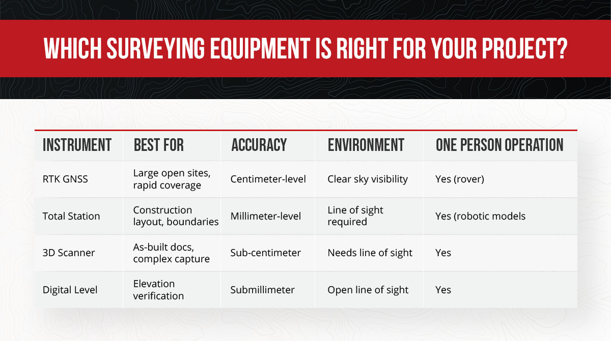
The right instrument depends on project type, environment and accuracy requirements.
| Instrument | Best For | Accuracy | Environment | One-Person Operation |
|---|---|---|---|---|
| RTK GNSS | Large open sites, rapid coverage | Centimeter-level | Clear sky visibility | Yes (rover) |
| Total Station | Construction layout, boundaries | Millimeter-level | Line of sight required | Yes (robotic models) |
| 3D Scanner | As-built docs, complex capture | Sub-centimeter | Needs line of sight | Yes |
| Digital Level | Elevation verification | Submillimeter | Open line of sight | Yes |
Large-Scale and Open-Site Surveys
The best type of surveying equipment for large-scale projects is RTK GNSS. This is because GNSS delivers rapid coverage with no line-of-sight limitations. One-person rover operation eliminates the setup and repositioning cycles that slow total station work on expansive sites.
High-Precision and Obstructed-Environment Work
Robotic total stations meet the demand for high-precision work and obstructed environments or where satellite signals are unreliable. Millimeter-level control isn’t optional in these contexts. Being slightly off can have structural, legal and financial ramifications, including rework, property boundary breaches and unreliable monitoring data.
As-Built Documentation and Complex Site Capture
As-built documentation, renovation planning and complex industrial sites demand comprehensive spatial data. Every surface, elevation and spatial relationship matters because incomplete capture means costly return visits or design conflicts during construction. 3D laser scanning captures comprehensive spatial data in one session, collecting millions of measurements that would take days or weeks with traditional point-by-point methods.
What Are the Best Field Supplies for Professional Surveying Teams?
Field supplies are the often-overlooked half of a productive survey kit. The right field accessories protect your instruments, keep crews safe and prevent avoidable delays.
Measurement Accessories and Safety Equipment
Core measurement accessories support accurate data collection in the field:
- Professional tripods: Stable platforms prevent instrument movement during measurements.
- Prism poles and bipods: Proper pole selection and stabilization improve target accuracy.
- Prisms and prism assemblies: Match prism type to your instrument and measurement distances.
- Tribrachs: Quality tribrachs enable precise instrument leveling and quick setup.
- Grade rods: Grade rods are essential for elevation work with digital and optical levels.
The right field surveying supplies help reduce setup time and protect measurement integrity.
Data Collection Accessories and Equipment Protection
Survey data collectors streamline field-to-office workflows by capturing, processing and transferring data without intermediate steps. Rhinotek-reinforced carrying bags and padded cases protect fragile scanning and robotic instruments during transport between jobsites.
Professional-grade instruments are built for real-world conditions with IP65 or IP67 ratings that handle dust, moisture and temperature extremes. Proper cases extend that protection to transit, preventing damage from vibration and impacts that occur during vehicle transport.
Build and Equip Your Survey Fleet With Monsen Engineering
Monsen Engineering has served surveying professionals across the Intermountain West since 1974, offering a comprehensive solution for instrument purchasing decisions. We provide the full range of surveying tools and equipment from industry-leading brands including Trimble, with decades of geospatial expertise behind every recommendation. Our hands-on training reduces learning curves on new technology, while responsive technical support and repair services protect your uptime.
Want to trial land survey equipment before committing to a purchase? Our rental program lets you validate fit for your specific workflows. When you’re ready to build or upgrade your survey fleet, contact Monsen Engineering to discuss your project requirements and find the right instruments for your team.