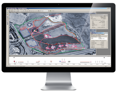
Trimble GPS Pathfinder Office
Powerful and easy to use GNSS data processing software
Sophisticated data dictionary editor ensures consistency between the field and the office
- Create custom lists of features and attributes for field data collection with the Data Dictionary Editor, or import a data dictionary from a GIS based on its exact data schema.
- Receive prompts in the field to enter specific information into data capture forms, ensuring data integrity and compatibility with the GIS.
- Create conditional attributes that dynamically adapt to previously entered attribute values, for maximum data collection efficiency.
Differential corrections to improve the quality of GNSS data collected in the field
- Use postprocessing to significantly improve the accuracy of data collected in the field all the way down to centimeter level (1 cm / 0.4 inch).1
- Supports the complete Trimble Mapping and GIS GNSS portfolio, as well as associated positioning technologies, such as Trimble H-Star™.
1 Depending on the environment and the GNSS receiver.
Quality control your collected field data
- Analyze collected features to confirm they are complete and accurate before exporting to a GIS, CAD, or database system. Review and edit GNSS positions and attributes for the highest quality data.
- Collected features can be compared against background datasets such as vector GIS data, aerial photographs or satellite imagery in order to verify accuracy and detect conflicts.
- Background data can be imported to GPS Pathfinder Office from GIS systems, directly from imagery files, or referenced directly from a WMS
Import and export data to a variety of GIS and CAD formats
- Verify and update GIS data previously collected in the field.
- Import data to GPS Pathfinder Office from a number of GIS and database formats.
- Export collected data and associated metadata to a number of GIS and CAD formats.
- Additional import and export formats supported via Trimble SSF and DDF data format extensions for FME


